NASA sees the Southern Indian Ocean cyclone season awaken

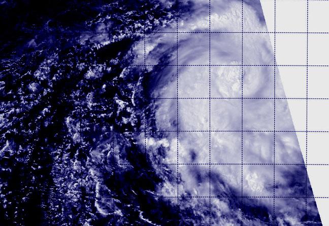
The first tropical cyclone of the Southern Indian Ocean cyclone season has formed over 300 miles from Diego Garcia. When NASA-NOAA Suomi NPP satellite passed over Tropical Storm Adjali the VIIRS instrument aboard took a visible picture of the storm that showed bands of thunderstorms wrapped around its center.
NASA-NOAA's Suomi NPP satellite passed over Tropical Storm Adjali on Nov. 17 at 09:56 UTC (4:56 a.m. EDT) and the Visible Infrared Imaging Radiometer Suite (VIIRS) instrument aboard captured a visible picture of the storm. The VIIRS image showed that the storm appeared to be coming together as circulation improved and bands of thunderstorms have been wrapping into the low-level center of circulation.
The Joint Typhoon Warning Center (JTWC) noted that animated multispectral satellite imagery showed bands have wrapped tightly into a defined, low-level circulation center with a slight, cloud filled, eye feature.
On Nov. 17 at 0900 UTC (4 a.m. EDT), Adjali's maximum sustained winds were near 55 knots (92.8 mph/102 kph). It was centered near 9.25 south latitude and 67.3 east longitude, about 334 nautical miles southeast of Diego Garcia. Diego Garcia is an island in the central Indian Ocean, and is part of the British Indian Ocean Territory.
Adjali was moving to the east-southeast at 3 knots (3.4 mph/5.5 kph). Forecasters at JTWC expect the storm to continue intensifying and turn to the southwest. However, it is expected to weaken before approaching La Reunion Island around Nov. 22 once it encounters cooler waters.
© MD News Daily.
